:::: MENU ::::
Posts tagged with: 3D

Agisoft PhotoScan

blog header, with images from Agisoft Photoscan

Agisoft PhotoScan (commonly known as PhotoScan) is a professional tool for a photogrammetry pipeline. It performs photogrammetric processing of digital images and generates 3D spatial data. Agisoft Photoscan is the dominant photogrammetric software on the market, being used by a range of professions, from archaeology, cartographers to creators of virtual worlds and game developers. Unlike Visual SfM, it contains a complete program to numerous specific tasks and different types of data, and, as a novice to photogrammetric software, was easily managed, with an efficient workflow system.

Continue Reading


Ogham in Animation

blog header with text animation

My original idea for an animation about Ogham Stones, was to create a virtual world, where Ogham Stones that have been relocated, could be returned to their original site in a virtual world. This could be applied to Ogham Stones, in Museums and other collections. An example of this is the Ogham Stones from Ballinrannig, Co, Kerry. In the late 1700’s a collection of seven Ogham Stones and a cross slab were revealed in Ballinrannig, Smerwick Harbour, Co. Kerry, when a storm shifted the sand covering them. Lord Ventry, of Burnham House, moved six of upright Ogham Stones, and a cross slab. He placed four of the stones along with the cross slab in his driveway.

Continue Reading


Visual SfM: 3D Construction through Structure from Motion

blog header with text Visual sfm

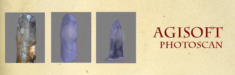
From reviewing the paper The Untapped Potential of Low Cost Photogrammery in Community-Based Archaeology, it was easy to see that photogrammetry can be used as an alternative to high resolution surveying with high costs.

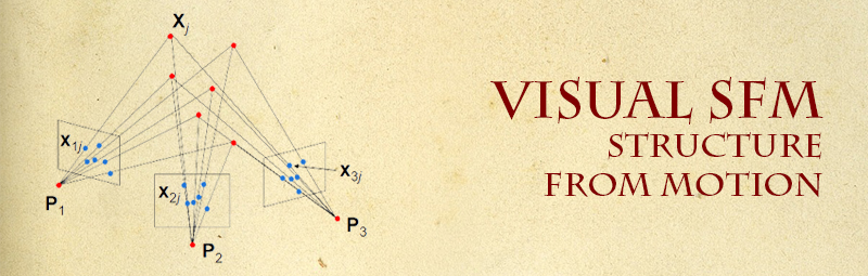
Traditional softcopy photogrammetric methods require the 3-D location and pose of the camera(s), or the 3-D location of ground control points to be known to facilitate scene triangulation and reconstruction. In contrast, the SfM method solves the camera pose and scene geometry simultaneously and automatically, using a highly redundant bundle adjustment based on matching features in multiple overlapping, offset images [Westoby et al 2012].

Structure from motion is the geometry of creating 3D models from 2D images. If you are interested in the maths behind SfM, visit Prof. Rob Fergus’s lecture notes on Computer Vision, or geometric vision, in particular Lecture 6 on Multiview Stereo & Structure from Motion.  It is quite interesting to see the process. Thankfully, to Wu Changchang, we don’t need to understand the mathematics behind how Structure from Motion works, to be able to use it. In his post-doc year at University of Washington Seattle, he developed Visual SfM.

Continue Reading


Review: The Untapped Potential of Low-Cost Photogrammetry in Community-Based Archaeology

2 images about the Inuit community Canada

          The Untapped Potential of Low-Cost Photogrammetry in Community-Based Archaeology: A Case Study from Banks Island, Arctic Canada, is a paper that was printed in the Journal of Community Archaeology & Heritage, in April 2016. Written by Colleen Haukaas and Lisa M. Hodgetts, this research paper is a case study from an archaeological project they undertook in Banks Island, Canada. It bears a striking resemblance to the Ogham in 3D project, in that it is a community orientated archaeological project, using photogrammetry and structure from motion techniques, and similar software for translating the data into 3D models.

Continue Reading


Burnham House

Image with 3D ogham stone and the text Ogham in 3D

I’ve finally begun the Ogham in 3D Mapping Project, (see previous post here). I have been assigned to map the Ogham Stones at Cólaiste Íde/Burnham House.

Burnham House, is a detached seven-bay three-storey late-Georgian house, built c. 1800. 1 Originally the estate of Lord Ventry, it is now an Irish speaking girls boarding school, Cólaste Íde. A collection of seven stones, they were though to have originally been situated at a few different sites, eg Ballinrannig; Burnham East, Ballineesteenig, and other sites, but were placed along the driveway by Lord Ventry.

Continue Reading


3D Mapping Project, Dingle

As a visual learner, I find it much easier to understand ideas and concepts if they are put into practice. I want to put my new skills and knowledge (with a whole lot of curiosity!) to some use, and physically see how Digital Culture can make an impact. I want to get my hands digitally dirty so to speak. I emailed our local Museum, Múseum Corca Dhuibhne, to see if there was any projects I could volunteer on. Either I had a skill that might be of some use, or I could upskill if necessary. I ended up meeting resident archaeologist and curator Isabel Bennett for a long chat about an exciting upcoming project, Ogham in 3D

Continue Reading


css.php